
Quick Look:
Name: Lookout Trail
Location: Km marker 39.7, Highway 60, Algonquin Provincial Park, Ontario, Canada
Length: 2.1 km (1.3 mi)
Elevation Gain: 71 m (233 ft)
Difficulty: Moderate – Difficult
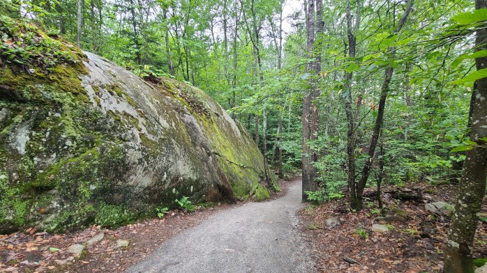
Features & Points of Interest: Scenic lookout, large rock outcrop, sheer cliff, well maintained forested path

Overview
The Lookout Trail, located in Algonquin Provincial Park, is a moderate to difficult 2.1 km loop that features a sweeping scenic lookout, large rock outcrop, and well-maintained forested path. Despite its relatively short length, this trail can pose a challenge for some due to its steep incline, and elevation gain. At a moderate pace, the hike can be completed in less than 1 hour.

What do you need to know?
Hikers will be rewarded with one of the best views in the entire area and a fantastic place to stop, catch your breath, and take an unhealthy amount of photos. Just be warned though, this trail is one of the most accessible in Algonquin Park, and as such will be one of the busiest. It’s best to hike the Lookout Trail earlier in the morning, or later in the afternoon to avoid the lunchtime and evening rushes.
If you’re planning on visiting during the Fall colours season, particularly on the weekend, know that the parking lot reaches over-capacity quickly, and the path becomes nearly unusable due to the congestion. To maximize your enjoyment, consider coming during the week, or visiting the park at a time of year when the crowds aren’t as numerous.


How to get here:
- From Toronto:
- Hwy 400 –> Hwy 11 –> Hwy 60 –> Algonquin Park West Gate –> km marker 39.7
- *Be sure to stop in at the West Gate to pick up your day pass*
Thank you so much for reading, and if you’ve made it this far please consider liking the post, sharing it with your friends, and hitting the follow button so you don’t miss any of my upcoming material! And don’t forget to follow me on Instagram, Facebook, Twitter, and Pinterest!
Enter your email address below to stay up-to-date on my latest posts!
Looking to start a blog? Earn a $25 credit towards a wordpress.com plan when you sign up using the affiliate link below!

I haven’t hiked this trail yet, but it looks nice. I bet it would be beautiful in the fall when all the leaves are changing colour.
LikeLiked by 1 person
It’s stunning with the colours, but like all areas in the park hwy 60 becomes a parking lot during the peak fall hours. Algonquin has to bring in the OPP to manage the excess of traffic or real issues start happening. Still worth it though if you don’t mindthe headache!
LikeLiked by 1 person